The Transfer You Cannot See on a Distance Map
A route can look short on a distance map and still feel awkward. Sketch each transfer to see where a journey loses ease and how to improve it.
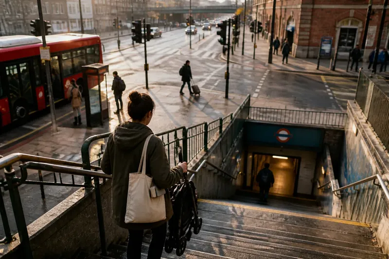
You leave a bus beside a busy road, but the train entrance is across a wide junction and down a flight of stairs. On a distance map, the two stops almost touch; on foot, the connection has become the hardest part of the journey. A transfer is the movement between modes or services, and its quality can matter more than the line between them.
To see why, consider an invented, hypothetical journey from a riverside neighbourhood to a public library in the centre. The map suggests a direct bus-and-train trip. By sketching the connections rather than tracing the whole route as one line, the traveller can spot where time, effort or uncertainty gathers.
Why does the transfer change the journey?
A distance map treats stops as points and routes as lines. It does not show whether a passenger must cross traffic, search for a platform, wait in an exposed place or carry a pushchair up stairs. Those details are not decoration around the journey; they are part of it.
A useful analogy is a chain of keys: the shortest chain is of little help if the link you need is awkward to grasp. A route can have a quick main leg and still feel difficult because one connection asks for extra walking, a confusing choice or a long wait.
The traveller in this invented situation is taking a folded pushchair and a library book bag. The bus stop is near home, and the train runs towards the centre, but the interchange is not a single doorway: it involves leaving the bus stop, crossing the road and finding the station entrance.
How can you sketch the connections?
Use a sheet of paper, a pencil and, if useful, a phone map for street names and stop locations. Draw a box for each stage where the traveller boards, changes mode or reaches the destination. Connect the boxes in order, leaving enough room to note what happens between them.
For each link, write down the mode and the action required to continue: walk to a stop, wait, board, get off, cross, find an entrance or change platforms. Add the conditions that could alter the experience, such as stairs, a signal-controlled crossing, a sheltered waiting area or signs that are hard to see from the arriving vehicle.
In the imagined journey, the sketch might read: home to bus stop; bus to interchange; walk across the junction; locate station entrance; descend to platform; train to central stop; walk to library. This is not a timetable or a precise route plan. It is a picture of the decisions and physical transitions the traveller must make.
- Mark the handover: Note exactly where one service ends and the next begins.
- Describe the walking link: Record crossings, stairs, lifts, ramps and changes of level.
- Note the wait: Distinguish an ordinary platform wait from a wait that follows a missed connection.
- Flag the decision point: Mark where a passenger must choose an entrance, direction or platform.
- Include the carried load: A bag, folded pushchair or mobility aid can change which path feels workable.
The point is not to turn every journey into a score. The sketch should help you ask where the route asks for effort, attention or extra time, and whether that demand is avoidable.
What does the imagined route reveal?
On the sketch, the bus ride and train ride appear uncomplicated. The awkwardness sits in the short link between them: the bus stop is on one side of a broad junction, while the station entrance is on the other, with no obvious sign visible from the stop.
Suppose the traveller checks the map and notices that another bus stop serves the same train station from the station side of the road. In this invented situation, they choose that stop instead, accepting a slightly less direct bus leg. The expected observable result is a transfer with no junction crossing and a clearer view of the entrance on arrival; the sketch makes the trade-off visible without claiming the whole trip is faster.
The second drawing also prompts a useful question: can the traveller reach the platform without stairs? If a lift or ramp is needed, its location and availability become part of the connection, not a separate detail. A map that draws only the train line cannot answer that question.
Which details should you check before choosing?
Look at the connection from the perspective of the person making it, rather than from the centre point of each stop. Street-level mapping can help identify crossings and entrances; signs at the stop, station plans and operator information can clarify where boarding and platform access happen. Where access depends on a lift, service notice or local arrangement, check the relevant operator’s current information.
Consider these questions while comparing possible transfers:
- Does the walking route follow a clear path, or does it require an uncertain shortcut?
- Can the passenger cross at a convenient place, or must they detour to a signal or refuge?
- Is there a choice between stairs and a step-free route, and is that route easy to locate?
- Will a late arrival mean a short wait in a comfortable place or a much longer interruption?
- Can someone carrying a load keep their bearings while moving between the stop and the entrance?
Each answer is specific to the traveller and time of day. A transfer that feels simple with a light bag in daylight may demand more attention in rain, with a child, or when signs are obscured by a crowd. The drawing can hold those conditions as notes, rather than pretending one route suits everyone.
What do readers often ask about transfer maps?
Is a transfer just a change from bus to train?
No. It can be a change between services on the same mode, or the walk between a station entrance and a stop outside. The important feature is the link a traveller must make to continue the trip.
Should walking time be included in a route sketch?
Yes, but describe the walk as well as noting its duration if you know it. A short walk with stairs or a difficult crossing may feel more demanding than a longer, direct path.
How do I compare two possible connections?
Draw both as separate sequences and compare the crossings, level changes, waiting places and points where a decision is required. Then consider which sequence best fits the traveller’s needs and the conditions they expect.
Can a distance map still be useful?
Yes: it helps orient you and shows where services run. Pair it with a connection sketch when you need to understand what happens between the lines and stops.
What can the sketch change in practice?
The invented traveller’s final choice is not a universal answer; it is a better-informed one. By drawing each handover, they have shifted attention from the apparent closeness of two stops to the crossing, entrance and platform access that shape the actual connection.
Try the same approach before a journey that feels oddly tiring despite looking direct. Keep the sketch beside the distance map: the map shows where the route goes, while the sketch shows how a person gets from one part of it to the next. That distinction can reveal a better connection even when the city’s lines stay exactly where they are.