The Repeating Block: What a City Grid Makes Easy to Notice
A repeating block makes a city grid easier to read, helping you compare routes, buildings and street life without mistaking the pattern for the whole city.
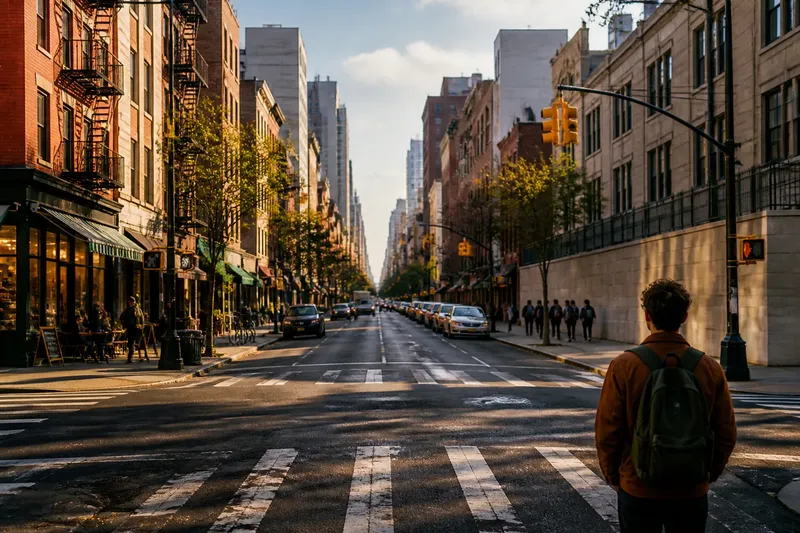
At a junction in central Manhattan, the next avenue can look much like the last: long façades, cross streets, traffic signals, then another run of buildings. A repeating block gives the eye a steady beat. It also makes differences unusually clear, from a market spilling onto one pavement to a quiet stretch with closed shutters.
That is one useful way to read a city grid: not as a promise that every street is alike, but as a framework for comparison. Repetition makes orientation easier and gives small variations somewhere to stand out.
What does a city grid make easy to read?
A grid arranges streets into recurring lines and intersections, often creating blocks of broadly similar shape. The pattern lets a pedestrian anticipate what comes next. After crossing one block, it is often possible to judge the direction and rough distance of the next turn without consulting a map.
That predictability is practical, but it also changes how the city is observed. When the route repeats, attention can move away from basic wayfinding and towards details: whether a street has trees, how many doors open directly onto it, where the pavement narrows, or which buildings have active ground floors.
In an unfamiliar district, notice the street names and the orientation of the blocks before walking far. A map may show avenues running in one direction and cross streets in another, but the view from the pavement confirms what the lines mean. A grid can still be interrupted by a diagonal road, a railway or a change in slope, so use the pattern as a guide rather than assuming every intersection will fit it.
How does repetition help you compare blocks?
Comparison works best when you attend to one feature at a time. Walk two adjacent blocks and look only at entrances, then repeat the route while noticing shade or ground-floor uses. The repeated street form acts like a plain ruler on a desk: it makes a difference easier to see without explaining why it exists.
For instance, the same avenue may have a bakery, a pharmacy and apartment doors on one block, then blank walls and vehicle entrances on the next. The contrast tells you something about how each stretch meets the pavement. It does not, by itself, explain ownership, planning decisions or the businesses’ prospects.
Keep notes concrete and local. “Few doors on the west side” is more useful than “this block feels unfriendly” if you want to compare the next stretch. A brief record of crossings, shade, shopfronts and places to sit can also help distinguish a change that persists from one that belongs to a single corner or building.
Say you are walking through a fictional district laid out in regular blocks, and the first two blocks have frequent shop doors while the third has a long school wall. If you note where the entrances stop, you can compare the school frontage with the blocks on either side. The observation may suggest a less varied walking experience along that stretch, while leaving open what the school needs from its boundary.
What changes from one block to the next?
Buildings give a grid much of its visible variation. Compare their height, frontage, setbacks and materials, but notice how those features meet the pavement. A row of similar brick façades can still produce different street scenes if some have stoops, awnings or doorways and others meet the footpath with uninterrupted walls.
Uses matter as well. A block with cafés, small shops or workshops may invite different patterns of stopping from one lined with homes or offices. That difference is not simply a matter of busyness: loading bays, school gates, clinic entrances and places of worship can each create distinct rhythms at particular times.
Look for time as another layer. A street that is active when shops open may become quieter later, while a school frontage changes as pupils arrive and leave. If you return at another time, treat the conditions as a fresh observation rather than evidence that one visit was mistaken.
Edges can vary even when the blocks themselves stay regular. A park, a canal or a large institutional site may occupy an unusually long frontage; a railway cutting may separate streets that appear close on a map. These boundaries interrupt the steady sequence and often explain why a route feels less direct than its block pattern suggests.
Where does a grid stop telling the story?
A plan shows street geometry, not the full experience of moving through it. Two blocks may look alike from above but differ in traffic speed, noise, maintenance, shade or how comfortable a crossing feels. The pedestrian view adds information that the map cannot supply.
Nor does a regular street pattern mean that movement is equally easy for everyone. A broad junction can be straightforward for a driver and difficult for someone using a wheelchair if the crossing surface is uneven or the signal timing is unsuitable. A steep incline, missing kerb ramp or obstructed pavement can matter more than the apparent simplicity of the grid.
Some places also resist the block-by-block way of looking. A market may spread across several streets; a park path can draw people through the middle of a block; a station may gather movement from several directions. In those settings, the activity or route may be the stronger organising pattern.
History and local decisions are present too, though they are not fully legible in the street layout. A regular grid does not reveal why one block has larger buildings, why a road carries heavy traffic or which residents have shaped the area. Treat visible patterns as clues to investigate, not as complete explanations.
How can you read a city grid on foot?
A short walk is enough to practise careful comparison. Choose a stretch where the blocks repeat, then keep the route simple so the details remain easy to remember.
- Find the pattern: Identify the direction of the main streets and cross streets, and note any diagonal route or obvious break.
- Choose one feature: Look for doors, trees, shopfronts, seating or crossings rather than trying to register everything at once.
- Compare neighbouring blocks: Ask what stays similar and what changes at the pavement edge.
- Notice movement: Watch where people pause, cross, queue or turn, without assuming one brief visit represents the whole day.
- Check the interruption: Look for a park, large site, slope, busy road or other boundary that alters the regular sequence.
- Record the limit: Note what the pattern cannot tell you, such as who uses a place at another time or why a frontage was designed that way.
Keep the route manageable and the notes modest. A small sketch can mark one intersection, the direction of travel and a few features on each block. The point is not to make a complete map, but to give comparisons enough context that they remain meaningful when you look back.
What questions help make sense of a repeating block?
Does a city grid make every route easy to follow?
No. Regular intersections can make direction easier to anticipate, but barriers, steep ground, traffic and unclear crossings may still complicate a walk. Check the route at street level rather than relying on the neatness of the plan.
Why can two similar blocks feel different?
Their frontages, uses, shade, noise and pedestrian activity may differ even when the street layout is alike. The contrast becomes clearer when you compare one feature at a time.
Is a grid always made of square blocks?
No. Blocks may be long, narrow, angled or irregular, and some street networks only partly follow a grid. Look for repetition in the street connections rather than expecting identical shapes.
Can the grid explain why a neighbourhood developed as it did?
It can show the arrangement of streets and blocks, but not all the decisions and histories behind them. Use the visible pattern to frame questions, then seek other local evidence for answers.
What is worth carrying forward?
On your next walk, use the repeating block to notice both its promise and its limits. It can make a route easier to anticipate and a frontage easier to compare, but it cannot tell you how a place feels at every hour or what produced its present form.
The most useful reading of a city grid stays close to what can be seen: a line of doors, a sudden wall, a shaded pavement, a crossing that draws people out of their way. Those observations make the pattern more than an arrangement on a map, without mistaking the arrangement for the city itself.